GPS Tracks Manual
 GPS Tracks Manual
.pdf
Select a Feature
- F.A.Q.
- How to Use the Functions on the Map
- Record Your Track
- Track Details and Editing
- Track Summary
- Track Goals
- AI Insights
- Navigate to a List of Waypoints
- GPS Tracks Pro Subscription
- GPS Tracks Live
- Track and Waypoint Sharing
- GPS Data / Compass
- Map Measurement Tool
- Rangefinder
- Map Overlays
- Track Guidance
- Adding and Saving Waypoints
- Folders, Favorites, Copy and Paste, and Drag and Drop
- Tags
- Create a Route Manually
- Convert Coordinates
- Send a Link to a Location
- Getting Directions
- Siri and Shortcuts
- Widgets and Live Activities
- Apple Watch
- Import
- Export
- Opening Files with GPS Tracks
- User Modes
- Settings
- Backup and Restore
- Troubleshooting
- x-callback-url
How to Use the Functions on the Map
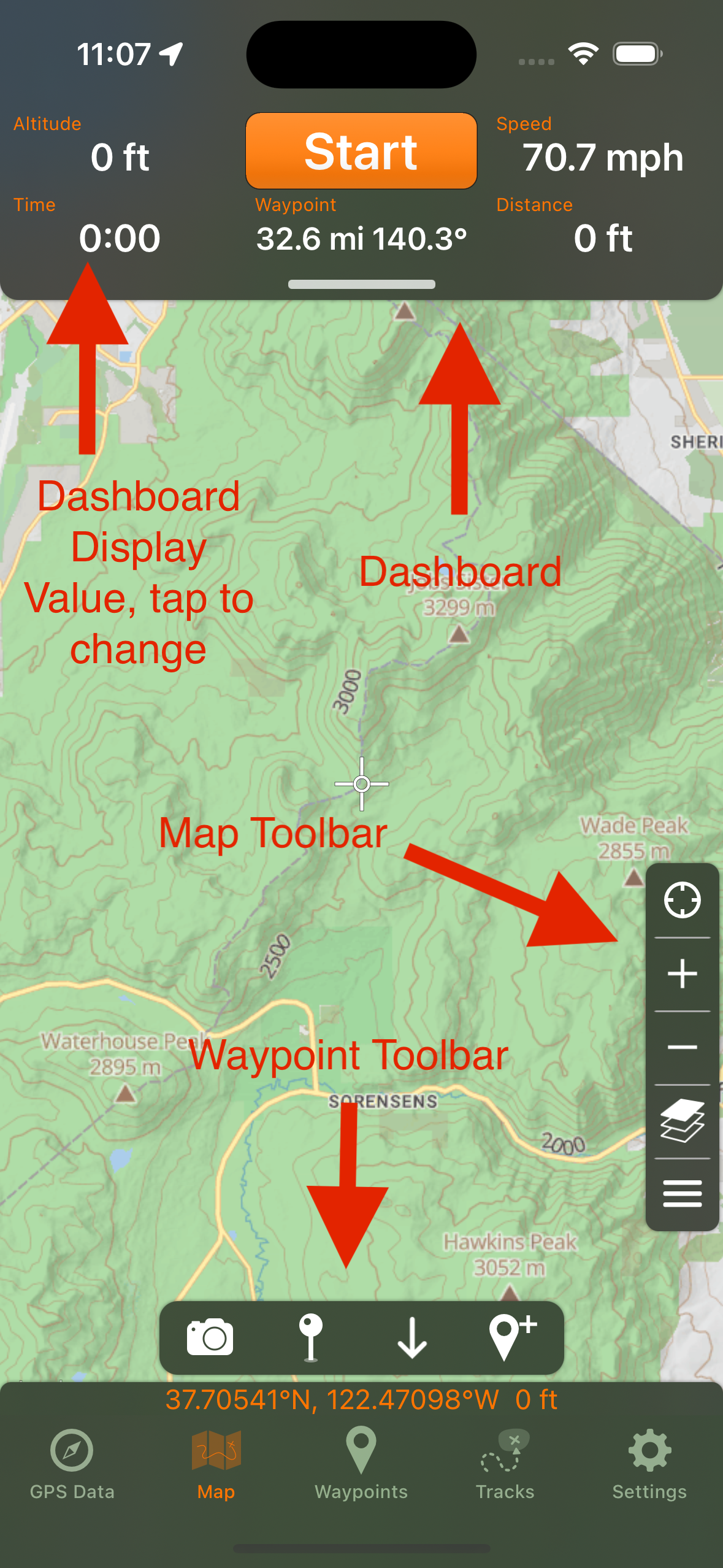
There are two main Map controls, the map toolbar and the map menu. The map toolbar can be found at the right side of the map and will contain items such as center user, zoom in/out, and map menu, measure, and search. The map menu can be accessed through either the toolbar or by long pressing on the map for 2 seconds to reveal the context menu.
Map Toolbar
The map toolbar can be found on the right side of the map. It is fully customizable, even to the point that it is not present. If you have removed the map menu function from the toolbar you can long press on the map for two seconds to reveal the context menu and subsequently access the map menu. See the list of functions that can be added to the map toolbar below.
- Center User Location
- Zoom In/Out
- Search Map
- Measure Map
- Rangefinder (Pro)
- Lock Screen
- Change Map Type
- Waypoint Toolbar (when Waypoint Toolbar in Side Toolbar is enabled in Settings)
- View Map Menu
Map Menu

The map menu can be accessed in two ways. Either from the map toolbar or by long pressing on the map for two seconds to reveal the context menu. The map menu has the following functions below.
- User Modes (Pro)
- View Waypoints on Map
- View Tracks on Map
- Tags on Map (Pro)
- Change Map Type
- GPS Tracks Live (Pro)
- Search for Waypoints
- Rangefinder (Pro)
- Print Map (Premium)
- Measure Map
- Get Directions for Track
- Go To Coordinates
- Mirror Watch App
- Create Route
- Import Files
- Lock Screen - locks the screen so accidental touches do not change the map while you are moving
Map Display Settings
The lower section of the map menu lets you show or hide items on the map. Use these switches to customize the map toolbar.
- Compass
- Waypoint Compass
- Weather Display (Pro)
- Dashboard
- User Location Button
- Zoom Buttons
- Waypoint Toolbar
- Search Button
- Measure Button
- Rangefinder Button (Pro)
- Lock Screen Button
- Map Type Button
- Map Menu Button
Map Types and Map Layers

Tap the Map Type button to choose the map. Apple Street, Satellite, and Hybrid maps, along with a Blank Map, are available to everyone. The GPS Tracks Pro subscription adds GPS Tracks Street, Topo, Satellite, Dark, and Light maps, NOAA Nautical Charts, FAA VFR/TAC and IFR charts, USGS, Open Street/Topo/Sea maps, TomTom, Thunderforest, AccuTerra, and ESRI maps, as well as your own custom map sources.
The Map Layers section lets Pro users draw Hillshading and Contours layers on top of any map type. The Map Overlays section shows your imported image overlays. You can swipe or long press on a map type to mark it as a favorite so it is easier to find.
Context Menu
The context menu can be found by long pressing on the map for two seconds. It contains three functions and it is not customizable.
- Add Waypoint at location of the tap
- Center User Location
- View Map Menu
Waypoint Toolbar
The waypoint toolbar allows you to create a waypoint in multiple ways.
- Take a picture using your current coordinates
- Drop a pin at your location quickly
- Drop a pin in the center of the map
- Create a waypoint manually
By default the waypoint toolbar is shown at the bottom of the map. If you would rather keep the bottom of the map clear, enable Waypoint Toolbar in Side Toolbar in the Advanced settings. The waypoint toolbar will then appear as a single button in the map toolbar on the side of the map.
Dashboard
If the dashboard is not present, then it can be shown in one of two methods. First you can tap near the top of the map to bring it into view. Second you can swipe down near the top of the screen on the visible bar to slide it into view. In landscape, tap or swipe from the left side of the map instead. The dashboard is fully customizable. You can tap any of the five data items to change the content. This is similar to the track view. Choose Distance and Bearing to Crosshair or Distance to Crosshair to see how far the crosshair in the center of the map is from your current location.
Coordinate Display
The coordinates at the bottom of the map show either your location or the center of the map, depending on the Map Coordinate Display setting. On iPhone with iOS 26 or later you can also choose to hide the coordinate display completely.
Map Download
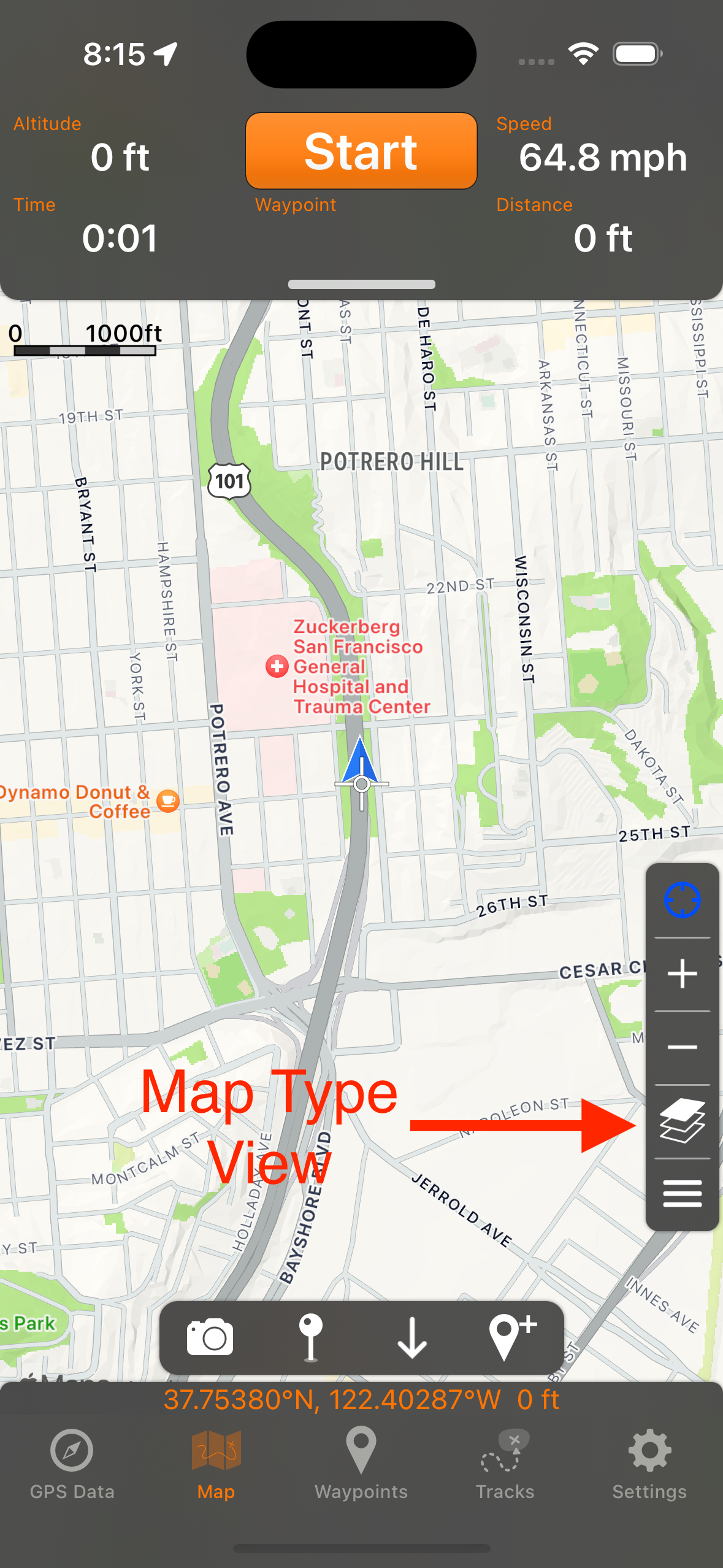
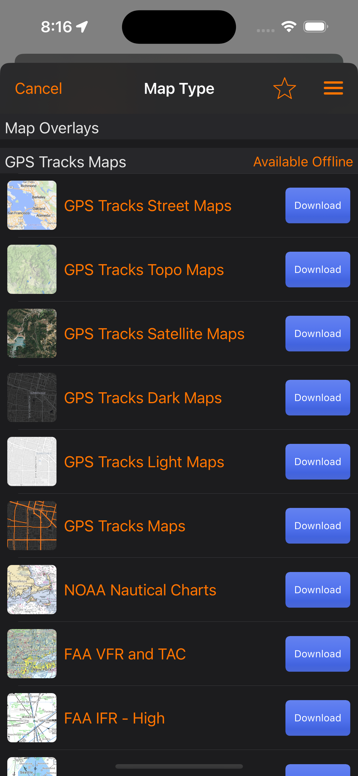
To download maps for offline use, tap on the Map Type button shown above. Then select the map type that you want to download and tap on the blue Download button. Each map type must be individually downloaded for offline use. If there is no blue Download button next to the map type then it is not available for offline use.
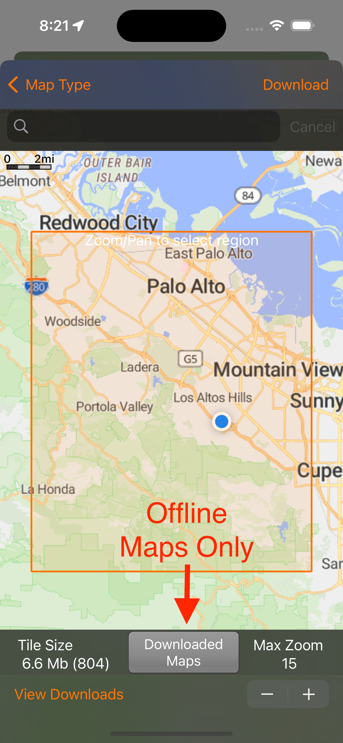
Once in the Download Maps view you can choose the area of interest by zooming and panning the map. The area inside the orange box will be downloaded. You can adjust the max zoom in the bottom right corner. If you want to see only locally stored maps, you can tap on the Offline Maps Only button notated above. When it is blue, the map will only show locally stored maps, when it is gray it will show all maps.
The app will automatically choose downloaded maps over maps from the internet so after you download them you dont have to worry about using offline maps, the app will do this automatically.
Record a Track
To record a track simply press the "Start" button on the top menu bar. This will start drawing a blue line on the main map along your current route.
To pause, or end the current track, press the "Stop" button on the top menu. This will bring up a pop-up menu with the option to "Pause", "Stop and Save", and "Stop and Discard". The "Pause" option will stop recording your track and it will turn off the GPS on the device if you put the app to sleep or switch to another app. The "Stop and Save" option will save the current track to your phone and discard your waypoints. The "Stop and Discard" will end the current track and discard all of the current waypoints.
Waypoints can be added at anytime during a track, as well as an imported or saved track from the Tracks tab. Waypoints that are on the map when the track is saved, will get copied and saved to the track. There is an option in the Settings tab named Keep Waypoints on Map After Save to have the waypoints remain on the map or removed when the track is saved.
The track width on the map can be adjusted in the Settings tab by either a fixed width or adjustable width depending on zoom level.
If Edit Track Details on Start is enabled in the General settings, you can set the track name, activity type, and folder as soon as you press Start.
Automatic Track Names
The Default Track Name setting chooses the name that is filled in when you save a track. You can use None, the Day of the Week, the starting Address, or one of several date formats. The Generate option uses Apple Intelligence on your device to create a short, descriptive name from the time of day, your location, the activity type, and nearby landmarks, such as "Morning Walk Along the Harbor". The Generate option requires a device that supports Apple Intelligence. If a name cannot be generated, you can still type your own.
Track Details and Editing


Select a track from the Tracks tab to open the track detail view. The graph at the top can be swiped up to show the full track details and statistics, including the time, distance, moving time, average speed, moving average speed, max speed, and elevation ascent and descent. Moving time and moving average speed leave out the time you were stopped, which gives a better idea of your pace when you took breaks along the way. The Track Splits section shows the time for each split, using the Split Distance from the Pro settings. If heart rate was recorded with the track, it can be used as a heat map option to color the track by heart rate.
Track Waypoints
Waypoints saved with a track are shown on the track map. Use the waypoint menu in the track detail view to View Waypoints in a list, turn Show Waypoints on or off to show or hide them on the track map, turn Show Waypoint Images on or off to show waypoint pictures as the map marker, and turn Show Splits on or off to show a marker at the end of each split on the track map (GPS Tracks Pro). Tap a split marker to see the split number, split time, distance, and average speed. Turn Show Stops on to mark the places on the track where you stopped for a minute or more, staying within about 30 meters (100 feet). Paused recording time counts as a stop. Tap a stop marker to see how long you were stopped. From the waypoints list you can add a waypoint, copy coordinates, navigate, get directions, start the rangefinder, send to the watch, duplicate or delete waypoints, add all of them to the main map, or save all of them to a waypoints folder. You can also copy waypoints from the list, or paste copied waypoints into the track. See Copy and Paste.
Track Menu
Tap the menu button in the upper right corner of the track detail view to access the following functions.
- Export, Email, ShareExport the track to a file, or choose Share Summary to share an image of the track. See Export and Share Track Summary below.
- Edit TrackEdit the track points. See Edit Track below.
- Merge TrackCombine this track with one or more other tracks into a new track. You can drag and drop the tracks to set their order before saving.
- Duplicate TrackCreate a copy of the track.
- Share OnlineUpload the track to your GPS Tracks account. See Track Sharing.
- Send to WatchSend the track to the Apple Watch app.
- Edit Track NameRename the track.
- Repair TrackFix common problems with the track data, such as duplicate track points. If you do not like the result, you can undo the repair from the same menu.
- Sync with iCloudManually sync this track to iCloud if it is missing on one of your other devices.
- Print Map (Premium)Print a detailed map with the track.
- Download Map Tiles (Premium)Download the maps that follow the track for offline use.
- Update Elevation (Pro)Replace the altitude data for the track with elevation data for the ground below it. This is useful for tracks that were imported without elevation or recorded with poor altitude accuracy. All of the current elevation data is overwritten, but you can undo the change from the same menu.
- UndoUndo the last change to the track, such as a repair or elevation update.
Share Track Summary
After you save a track, GPS Tracks shows an image of the track with its stats that you can share. Use the menus at the top to share This Track, a recap of This Week, or a recap of This Month, to choose the map style (No Map, Standard, Satellite, or Hybrid), and to choose the Square or Story format. Tap Share to send the image. Tap Don't Show Again to stop showing the screen after saving tracks, you can turn it back on with Show Share Screen After Saving in the Advanced settings. You can share the summary of any saved track by choosing Export, Email, Share and then Share Summary from the track menu.
Edit Track
Edit Track has three edit modes, which you can choose with the Edit Mode button (the scissors button) in the upper left corner.
- TrimChoose the start and stop points to keep a section of the track and remove the rest. The selected section must contain at least two points.
- Insert PointsTap a point on the track, then tap the map to insert new points after it. Tap Add when you are finished.
- Move PointsTap a point on the track to select it, then drag it to its new location. You can move as many points as needed.
When you are finished, you can save the changes to the current track or save them as a new track. You can also exit without saving to discard the changes.
Track Summary

The Track Summary shows all of the tracks in a folder together on one map along with the combined statistics. To open it, select a track folder in the Tracks tab, tap the menu button, and choose View Track Summary.
The summary includes the dates of the tracks, the track count, total distance, total time, average distance, average time, average speed, max speed, and altitude ascent and descent. You can share the summary with the Share Summary button. Tap Exit Track Summary to return to the folder.
Track Goals

A track goal lets you pace yourself against a previous track. To add one, long press on any track in the Tracks tab and choose Add Track Goal to Map. By default the goal uses the timing of the original track. You can change the total time or the speed to set a different pace, and you can turn on Reverse to follow the track in the opposite direction. Tap Add to place the goal on the main map.
While you record your track, a marker moves along the goal track at your target pace so you can see if you are ahead of or behind your goal. When you pause your track, the goal pauses as well.
AI Insights
AI insights uses Apple Intelligence to write a summary of your recent activity at the top of the Tracks and Waypoints lists. The track summary covers the tracks in the folder from the last 30 days, compared to the 30 days before, and includes the total distance, time, moving speed, max speed, and ascent and descent. If there are no tracks in the last 30 days, it summarizes your 10 most recent tracks. The waypoint summary covers the waypoints you saved recently.
Tap the insights card to see the full summary, with a map of the tracks or waypoints, highlights, and stats. Tap Regenerate to write a new summary. The summary is generated on your device with Apple Intelligence and may contain mistakes. The summary is updated when you add or change tracks or waypoints.
AI insights requires iOS 26 or later on a device that supports Apple Intelligence, with Apple Intelligence turned on. To turn the insights off, turn off Show AI Insights in the Advanced settings.
GPS Tracks Pro
If you need access to offline maps or if you need access to your private map tile server, GPS Tracks Pro subscription is perfect for you! GPS Tracks Pro is an auto-renewing yearly subscription. You need to download the maps first before using them offline, as you cannot download them while there is no internet connection. GPS Tracks Pro allows you to download up to 200 Mb of map tiles per download. There are no limits to the number of downloads.
Here is a list of Features for the GPS Tracks Pro subscription
- Access to GPS Tracks MapsAccess Street, Satellite, and Terrain maps, the most up to date Open Street Maps available. The maps are constantly updated and are available to store on your device for offline use.
- Use Custom Map Source URLsUse your own map tile server or any other map tile server available on the internet. The format is http://{a-d}[or]{0-3}.somservername.com/{z}/{x}/{y}.png. If your server provides 512 pixel tiles, enable the High Resolution (512 tile size) option for the custom map.
- Hillshading and Contours Map LayersDraw hillshading and contour lines on top of any map type from the Map Layers section of the map type view.
- RangefinderFind the distance and elevation between any two points on the map. See Rangefinder.
- Waypoint Range CirclesDraw up to five concentric range circles around each waypoint on the map.
- Compass StylesChoose from CDI, Fixed Bearing, Two Needles, Radar, Sun & Moon, Heading Tape, and Glide compasses in the GPS Data tab and on the Apple Watch. See GPS Data / Compass.
- Access to Alternate Map SourcesIn addition to GPS Tracks maps, there are also other map tile servers available to use such as TomTom Satellite, Thunderforest, and Accuterra.
- GPS Tracks LiveThis allows you to share your location in real time with your friends. Premium users can share their location with any users with a GPS Tracks account. Pro users can only share their location with other Pro users.
- Track SharingShare and store your favorite tracks online. You can share tracks with your friends or use for yourself. Pro users can store up to 25 tracks and Premium users can share 250 tracks.
- Waypoint SharingShare waypoints and waypoint folders online with your friends. See Track and Waypoint Sharing.
- TagsTag tracks, waypoints, and overlays to group them across folders, filter lists by tag, and show tags on the map. See Tags.
- User ModesSave the map dashboard and settings for an activity and switch between them. See User Modes.
- Offline Maps on Apple WatchSend downloaded maps to the Apple Watch to use without a connection. See Apple Watch.
- Elevation for WaypointsWhen adding waypoints that are not your current location, the app will retrieve the elevation.
- WeatherWeather will be displayed for each waypoint. This will allow you to add a waypoint anywhere to view the weather at that point.
- Subscription SyncThis subscription will sync over iCloud for use with GPS Tracks HD (iPad version) or any other device with GPS Tracks installed. You must be signed into the same iCloud account on both devices to sync.
GPS Tracks Premium
The premium subscription has all of the same great features of the pro subscription with the addition of the ability to download up to 1 Gb of map tiles at once, with no limit on the number of downloads.
Here is a list of Features for the GPS Tracks Pro subscription
- Download 1 Gb of map tiles at onceThis will allow you to download the maps tiles at a faster rate compared to the Pro subscription.
- Download Premium mapsThis will allow you to download TomTom Satellite, Thunderforrest, and Accuterra for offline use.
- GPS Tracks LiveWith the Premium subscription you can share your location with any user with a GPS Tracks account, they do not need the Pro subscription to follow you.
- Track SharingShare and store up to 250 tracks online.
- Print MapsThis will allow you to print details maps along with your track or waypoint overlays.
- Download Maps for TracksThis will allow you to download maps that follow a selected track or group of waypoints compared to a block of map tiles.
- Shapefile ImportImport ESRI shapefiles (.shp) as waypoints and tracks. See Import.
You can manage your subscription from the link in the app or through iTunes. The subscription auto-renewal can be turned off at anytime although subscriptions are generally not available for refunds. The maps are provided by third party companies, these companies can change there policy and/or terms of use which may require them to be removed from the app.
Download Maps for Offline Use
To download maps for offline use, tap the blue Download button next to the maps that you want to download from the Map Selection view. Place the desired map area in the Orange shaded box on the screen, then select the Max Zoom. The max zoom will ranges from 0 - 18, the bigger the Max Zoom, the larger the download and conversely the smaller the area that can be downloaded. When you are ready hit the Download button in the upper right corner to begin. It may take some time to download if you connection is slow. You can always leave the screen to pause it and resume from the View Downloads view.
Once the maps are downloaded you can tap on the View Downloads button to verify that they downloaded. From here you will see a list of all of your downloads. You can tap on any of them to view separately. In this view you will only see the map tiles that are on your device locally. By viewing them this way you can verify that they are on the device. The intent of this view is to verify that the maps have downloaded, once you verified that they downloaded, go back to using the app like normal. The app will use the downloaded maps seamlessly while you are using the app. It first will check the local maps folders, if they are not present then it will try to download it from the internet.
Clear Cache
You can clear the downloaded maps from the View Downloads view as well as the Temporary Cache. To remove downloaded maps, tap the Edit button and then select the map tiles to delete. The temporary cache is stored on the device for maps that are able to be downloaded. This will enable you to use these maps when you are offline even if you did not download them specifically. Since these files are stored in the cache, they could be deleted by the device if you run low on storage. You can clear this cache yourself by tapping the Clear Temp Cache button.
GPS Tracks Live
GPS Tracks Live allows you to share your location in real time with friends. You can set this to always share your location or only when recording which is the default. You can also set the app to record your friends tracks as they happen.
Premium users can share their location with any users and Pro users can only share their location with other Pro users. Anyone who wants to follow you needs an account as well. If you have the Premium subscription, then the other users do not need a subscription to follow you. If you have the Pro subscription the other users would need the Pro subscription.
GPS Tracks Live view can be found from the map menu button or in the settings tab. You can edit your user name and image from the GPS Tracks Account view at the top of the settings tab.
You must create a GPS Tracks account to use this feature. Once you have created an account you can only share your location with your friends in GPS Tracks. To add a friend, tap on the Add Friend button in the upper right corner of the GPS Tracks Live view from the Settings tab. Note that the other user must have a GPS Tracks account as well. You will need the email address they used to create their account to add them. Friend relationships only need to be added once, there is no need for your friend to repeat this process, but they must accept your request on their account.
Your friends' tracks are drawn on the map as they are recorded, along with their current speed. The menu in the GPS Tracks Live view lets you enable or disable all friends at once, share a link, or choose Visit gpstracks.app to open the GPS Tracks website. Links to gpstracks.app, such as the account verification email, open directly in the app.
GPS Tracks Live Settings
The settings can be found in the GPS Tracks Live section by tapping on your name at the top. By default tracking only happens when you are recording a track. You can change this to Always if you prefer. The other setting will determine if you want to record your friends track and save it to your device.
GPS Tracks Live Troubleshooting
You can toggle the switch next to the friend to reset the track as well as the stream if you run into issues.
Track and Waypoint Sharing
To share a track, select the track from the track folder to view the track details. Then tap on the track details menu button in the upper right corner and choose the Share Online option. This will upload the track to your account. Pro users can share up to 25 tracks and Premium users can share up to 250 tracks.
Your Tracks
To view your shared tracks, go to the track folder view and tap on the menu button in the upper right corner and choose the View Your Tracks Online option. From here you can change the sharing status or delete the track.
If you want to edit a track, you need to edit the local track and upload it again, it will overwrite the track on the server.
Friends Tracks
To view tracks shared by your friends, go to the track folder view and tap on the View Friends Tracks Online option. From here you can download tracks of interest.
Sharing Folders
To share a whole track or waypoint folder, long press on the folder and choose Share Folder Online. The folder and everything in it are uploaded to your account. Shared folders are listed by folder in the online views, and items shared with a folder show Shared through folder.
Waypoint Sharing
Waypoints are shared the same way as tracks (GPS Tracks Pro). To share waypoints, choose Share Online from the menu of a waypoint, or select waypoints in a waypoint folder and choose Share Online. You need to be signed in to your GPS Tracks account to share waypoints.
To view your shared waypoints, go to the waypoint folder view, tap on the menu button in the upper right corner and choose View Your Waypoints Online. From here you can change the visibility of each waypoint or folder to None, Friends, or Everyone, download them, or delete them from your account. To share waypoints with your friends, change their visibility to Friends. Deleting waypoints online does not delete the waypoints saved on your devices.
To view waypoints shared by your friends, choose View Friends Waypoints Online from the same menu. Select a waypoint to see its details, or download one or all of the waypoints into one of your waypoint folders. Waypoints that are already saved on your device are skipped.
GPS Data / Compass
The GPS Data tab is used to navigate to the next waypoint with the compass as well as view the statistics of the current track and position.
Waypoint View
The top view displays the next waypoint name, distance, bearing, and estimated time of arrival. You can tap this view to open the waypoint view page to edit, check-in, or remove it. When a waypoint is present a Check-In button will appear in the bottom right corner, you can tap this button to indicate that you are finished with the current waypoint and are ready to proceed to the next waypoint. The waypoint will be added to the Previous Waypoints list and the second waypoint will become the current waypoint. To view the list of Waypoints you can tap the Waypoints button at the top of the Map tab.
Statistics Views
There are eleven different statistics that can be displayed, but only four can be shown at once. To change any of the views, simply tap on it and select the new item from the list that appears at the bottom.
- Track TimeThe total time for your current track.
- Current TimeThe current local time.
- Track DistanceThe total distance for your current track.
- AltitudeThe current altitude.
- Elevation AscentThe total ascent during the track.
- Elevation DescentThe total descent during the track.
- GPS AccuracyThe current GPS horizontal and vertical accuracy.
- Speed/PaceThe current speed/pace. This will change according to the Speed Display value in the settings.
- SpeedCurrent speed.
- PaceCurrent pace.
- Average SpeedAverage speed.
- Average PaceAverage pace.
- Glide RatioThe ratio of distance / altitude.
- SlopeThe ratio of you current altitude and distance traveled.
- Slope AngleThe angle of the altitude divided by distance.
- Glide Angle to WaypointThe vertical angle to the next waypoint.
- PressureCurrent pressure as measured by the device.
- Distance to End PointThis is the sum distance of all the remaining waypoints in order.
- ETA to End PointThe estimated time of arrival to the last waypoint.
Compass
The compass can either display your current heading, which is the direction that the device is facing, or it can display your current course heading, which is the direction that you are currently traveling. To change to either the heading or course, just tap the compass, the current setting will be displayed at the bottom of the compass.
If there are waypoints on the map, the compass will display an orange arrow to point in the direction of the next waypoint on the map. To see the next waypoint on the map, tap on the waypoint list button in the toolbar at the top of the Map tab. The first waypoint in the list is the next waypoint, which the compass will indicate with the orange arrow.
Compass Styles
Tap the compass style button in the bottom right corner of the compass to choose a different compass. The button shows the icon of the current style. The standard Compass is always available, the other styles require GPS Tracks Pro. Each style shows two values in the corners of the compass panel, and tapping any style still switches between heading and course.


- CompassThe standard compass with an arrow to the next waypoint.
- CDIA course deviation indicator that shows how far you are off the course to the next waypoint. The corners show the cross track error (XTE), left or right of course, and the course (CRS) to the waypoint. The back bearing is shown at the bottom.
- Fixed BearingFollow a bearing that you lock. From the compass style menu, choose Lock Current Heading to lock the direction you are facing, or Enter Bearing to type a bearing in degrees or mils, depending on the Compass Display setting. Choose Clear Bearing to remove it. The corners show your cross track error and the locked bearing.
- Two NeedlesOne needle points to the next waypoint and a second needle points to the waypoint after it, or back to the start of your track when there is only one waypoint. The corners show the name and distance of each.
- RadarShows your waypoints, the start of your track, and your GPS Tracks Live friends around you. The waypoint you are navigating to is shown in green. The closest 25 items are shown. The corners show the radar range and the name and distance of the nearest item.
- Sun & MoonShows the direction of the sun and moon, as well as the sunrise and sunset directions. The corners show the time of the next sunrise or sunset and the current sun elevation.
- Heading TapeA horizontal heading strip that also tells you how far to turn left or right to face the next waypoint.
- GlideShows the height you will arrive at the next waypoint at your current glide ratio. The corners show the glide ratio required to reach the waypoint and your arrival height, which is shown in green when you can reach the waypoint and in a warning color when you cannot.
The CDI and Glide styles only have something to show while navigating to a waypoint. Until there is a waypoint, the standard compass is shown and the menu displays Shows while navigating to a waypoint under these styles.
 View Current Track Statistics
The View Current Track Statistics button is found right above the heading display denoted by the graph icon. This function is used to display the statistics of your current track being recorded. If no track is being recorded this view will be empty.
 View Current Location
The current location can be viewed by pressing the button with the crosshairs icon. When finished simply swipe the view down to remove it from the display.
Copy Your Coordinates

To copy your current coordinates, long press on the coordinates below the compass and select Copy Coordinates. The coordinates are copied in your selected coordinate format so you can paste them into another app.
Map Measurement Tool
The Map Measurement Tool can be found in the Map tab and enabled by selecting the Ruler button on the right side of the view. It can be used to measure area, distance, and route distance. You can create measurements by either dropping a pin on the map or by drawing with your finger. The units available are miles, feet, kilometers, meters, nautical miles, and yards.
Measurement Modes
There are two modes of measurement. These modes can be used interchangeably in the same measurement.
- DropIn this measurement mode you simply tap the map to create a measurement point. Each point is used to create a new measurement.
- DrawIn this mode, your finger is used to create new measurement points.
Measurement Types
The three types of measurements are area, distance, and route distance.
- AreaThis will measure the area enclosed in the polygon on the map.
- DistanceThis will measure the total distance between all the measurement points on the map.
- RouteThis measurement type will first calculate a driving/walking route between the points and then calculate the distance along the route.
Rangefinder

The Rangefinder (Pro) finds the distance and the elevation difference between any two points on the map. Start it from the Rangefinder option in the map menu, from the Rangefinder button in the map toolbar, or from Start Rangefinder in a waypoint's menu to measure from that waypoint.
While the map is locked, drag your finger on the map from the start point to the end point. The end pin follows your finger and the range and elevation are updated as you move. Unlock the map to pan and zoom, then lock it again to continue measuring. Use the rangefinder controls to change the units (miles, feet, kilometers, meters, nautical miles, or yards), lock or unlock the map, clear the current measurement, or exit the rangefinder.
Map Overlays

Map overlays let you place an image, such as a trail map, park map, or site plan, on top of the map. Overlays are found in the Map Overlays section of the map type view, where you can browse your overlay folders. To add one, open the menu in the upper right corner of the map type view, tap Add New Overlay, and choose Import from Folder, Import from Photos, or Take Picture. You can import JPEG, PNG, HEIC, TIFF, and PDF files. Importing overlays requires GPS Tracks Pro.
Positioning an Overlay
After you choose an image, make sure the lock control is set to unlocked, then pan, zoom, and rotate the map under the image until they line up. Tap the lock to fix the image in place on the map. Use the Transparency slider to see the map through the overlay. You can change the location and transparency later from the overlay details.
Georeferenced Overlays
GeoPDF and GeoTIFF files contain their own location data. When you import one of these files, GPS Tracks places it in the correct location on the map automatically, including rotated maps. This works with geospatial PDFs exported from Esri ArcMap/ArcGIS, USGS, QGIS, and Avenza. You only need to adjust the transparency and save.
Overlay Menu
From an overlay folder you can add or remove one or all overlays from the map, show or hide overlay names, sort the overlays, import, export, sync with iCloud, print the map, or download the map tiles for the area under the overlay.
Track Guide
The track guide tool will give you voice guidance when enabled. To enable it just tap on the Get Directions for Track function in the map menu. There are four options. The first option on the left will keep you centered and oriented up while it is enabled. The second option on the left will enable or disable voice commands. The third option will show the calculated turning points along the track. The fourth option runs the track in reverse.
Adding Waypoints
There are seven ways to add waypoints to the map.
- Manually Enter CoordinatesSelect the "+" button from the top menu bar. This defaults to your current location.
- Take a PictureSelect the camera button from the Map Tools menu at the bottom of the Map tab. This will take a picture and attach it to a waypoint on the map at your current location.
- Search for Points of InterestSelect the magnifying glass in the Map Tools menu at the bottom of the Map tab. Then use the searach bar at the top to find points of interest. Tap on the pin and hit the add button to save the waypoint.
- Tap Your Current Location Blue Arrow/DotTap the blue dot on the map and then select the blue round button on the right side of the pop-up.
- Drop a Pin on the MapSelect the Down Arrow from the top menu bar. This will drop a pin on the map. Use the orange arrow to help guide the placement of the pin. Then tap the pin and select the round blue button on the right side of the pop-up.
- Insert Saved Locations as WaypointsSelect the Waypoints tab from the tab bar. This gives you a list of folders or groups of locations. Select a folder to bring up a list of saved locations. Select a location to add it to the map as a waypoint. Select the menu button at the bottom tool bar and select the "Add all Waypoints to Map" to add all of the waypoints in the current folder to the map as waypoints.
- Open Files from Mail or SafariIf you open a KMZ, KML, or GPX file from your mail application or a KMZ, or KML file form Safari it will add any placemarks that are contained in the file as waypoints and add any route as a green track to the map. GPX files cannot be opened from Safari.
Add Waypoint View
The Add Waypoint view will appear when you add a waypoint from any of the first three methods above. It will allow you to edit the Name of the waypoint. You can select the coordinate type from the bar below the table. The definitions for the coordinate types are below -
- Dec - Decimal
- Dm - Degree-minute
- DMs - Degree-Minute-second
- MGRS - Military Grid Coordinate System
- UTM - Universal Transverse Mercator
You can choose to insert the waypoint as the next waypoint or the last waypoint. The exact order of the waypoints can be edited in the Waypoints view on the left menu.
You can choose to add the waypoint as a point or as a vector. Adding a waypoint as a point will allow you to edit the exact coordinates of the waypoint. Adding a waypoint as a vector will allow you to enter a direction and distance as a waypoint.
Saving Waypoints to Your Device
You can save any waypoint to your device for future use. Waypoints will be removed from the map if you either save your track or discard the track. Waypoints will be saved with the track but will not be very accessible. To securely save a location you must save it to the device.
To save a waypoint to your device select the "Save to Favorites" button in the Add Waypoint view. In the Save to Favorites view you must select a "Group" or folder where the location will reside.
Add Waypoints From the Waypoints tab to Main Map
To add a waypoint from the Waypoints tab, simply select it from the list in the Waypoints tab. This will add a COPY of the waypoint to the map in the Map tab. This means if you add any notes to the waypoint or update the coordinates then it will not be saved back to the Waypoints tab. In order to save it back to the Waypoints tab you must view manually save it to the desired location. However, it will be saved with the current track to the Tracks tab with all the updates.
Check-In
When you reach a waypoint, the app asks if you would like to check-in to that waypoint. If check-in is selected then the current waypoint gets added to the previous waypoints list and the next waypoint is now the current waypoint.
Taking Waypoint Pictures
When you take a picture for a waypoint, the camera opens full screen. Use the zoom controls in the camera view to zoom in before you take the picture. The waypoint is created at your current location with the picture attached.
Copying Waypoint Information
From the waypoint view you can copy the waypoint's name, address, notes, or coordinates to the clipboard to paste into another app. Copy Coordinates is also available when you long press on a waypoint in the Waypoints tab.
Waypoint Range Circles
Pro users can draw up to five concentric range circles around each waypoint on the main map. Set the number of circles with Waypoint Range Circles in the Pro settings. The Waypoint Range Circle Radius sets the spacing between circles, so a radius of 0.5 mi draws circles at 0.5 mi, 1.0 mi, 1.5 mi, and so on. You can also choose the color of the circles.
Waypoint Names and Lines on the Map
Waypoint and track names can be displayed on the map. You can change the text size and the text color of the names in the Map settings. The Automatic color uses black or white depending on the map type.
The Waypoint Line Style setting draws an orange dotted line between the waypoints on the main map. None hides the line, First connects your location to the first waypoint, All connects your location and all of the waypoints in order, and All - Exclude User connects all of the waypoints without connecting to your location.
Folders, Favorites, Copy and Paste, and Drag and Drop
Favorite Folders

You can mark waypoint and track folders as favorites so they are easy to find. Long press on a folder and choose Add to Favorites. Favorite folders are marked with a star. To show only your favorite folders, tap the sort menu and select Favorites under Filter. To remove a folder from your favorites, long press on it and choose Remove from Favorites.
Copy and Paste
You can copy waypoints and tracks and paste copies of them into another folder or track. The original waypoints and tracks are not changed.
- CopyOpen a waypoint or track folder, or the waypoints list of a track, and tap Edit. Select the waypoints or tracks you want, then tap Copy. The Copy button shows how many items are selected.
- Paste WaypointsOpen a waypoint folder and choose Paste Waypoints from the menu, or long press on a waypoint folder in the folder list and choose Paste Waypoints. The waypoints are added to the end of the folder.
- Paste Waypoints into a TrackOpen the waypoints list of a track and choose Paste Waypoints from the menu. The waypoints are added to the end of the track's waypoints.
- Paste TracksOpen a track folder and choose Paste Tracks from the menu, or long press on a track folder in the folder list and choose Paste Tracks. The tracks are copied into the folder along with their waypoints and overlays.
The paste options only appear in the menus after you have copied waypoints or tracks, and they show how many items will be pasted. Waypoints copied from a folder become track waypoints when pasted into a track, and track waypoints become regular waypoints when pasted into a folder. Pasted items stay on the device you copied them on. If you paste into another app, the waypoints are pasted as their names and coordinates, and the tracks as their names.
Drag and Drop
GPS Tracks supports drag and drop, which is especially useful on iPad and Mac.
- Drag a waypoint, track, or folder from a list and drop it on the map to add it to the map. Dropping a folder adds everything in it. This can be undone in one step.
- Drag files from the Files app or another app and drop them on the map or on a folder list to import them. Files dropped on a folder are imported into that folder. Files dropped on the map, or anywhere else in the list, are imported into new folders.
- Drag and drop waypoints in the View Waypoints on Map list to change their order.
- Drag and drop track points in Edit Track to move them.
Filter by Date
Tap the sort menu in a track or waypoint list and choose Filter by Date to show only the items from today, this week, this month, or this year, or choose Custom Dates to pick your own range. Choose All Dates or Clear Filters to show all of the items again. The sort button is filled in while a filter is on.
Create a Route Manually
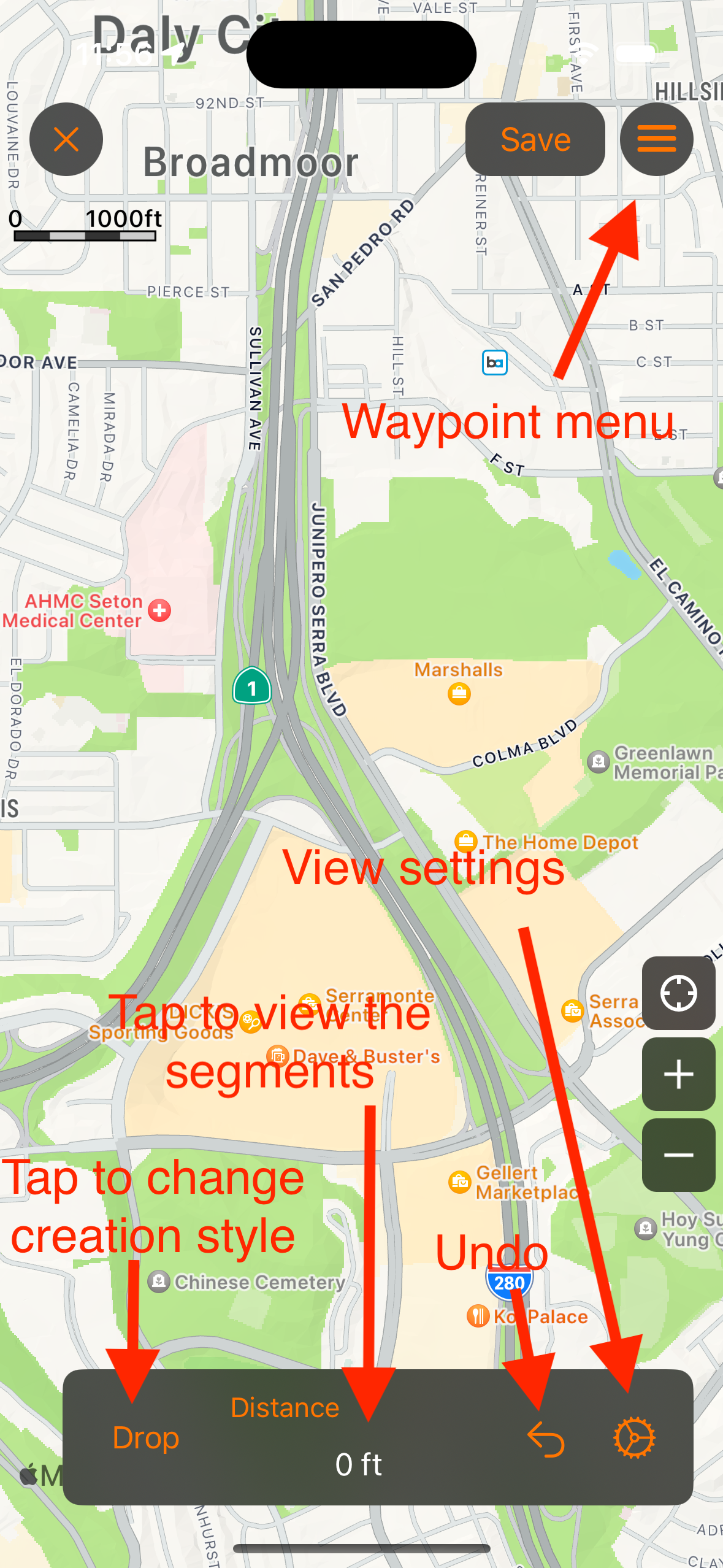
To create a route manually go to the Map tab and select the map meu button on the right side of the map. Any tracks or waypoints on the map will be shown in the create route map view as well. They can optionally be turned off from the create route view settings.
You can create the route using two different methods. The first method is to drop pins on the map and the app will create a route between the two pins. You can add as many pins to the map as needed. Use the Snap to Roads option to create a route along the roads or deselect it to create a route that simply connects the pins directly.
The second method to create a route is by drawing a line on the map. You must first enable drawing by tapping the raw option at the top, then pan/zoom the map in position. When you are ready tap the Draw button at the bottom. When finished drawing tap the End Drawing button. You can pan/zoom the map and begin drawing again if needed. The Snap to Roads option will create a route along the roads or you can deselect this option and create a route along the exact line drawn on the map.
Adding waypoint to the route can be done by entering the waypoints manually by tapping the add button in the waypoint menu in the upper right corner or you can long press directly on the map. To view a list of waypoints on the map, tap the waypoints menu button at the top and select View Waypoints. You can also include the waypoints brought in from the main map to be included with the new track from the view settings menu.
The view settings menu included the ability to hide or show the waypoints and tracks from the main map. The option to include the waypoints. The snap to roads toggle option. and the Driving, Walking, or Cycling directions type. Cycling creates the route along roads and paths suited for bicycles.
menuConvert Coordinates
To convert a coordinate to a different coordinate set, simply select the "+" button from the top menu and enter the coordinate that you would like to convert in any of the five available coordinate systems. After you have entered it in then select the coordinate system that you would like to convert it to.
When you are finished you can select "Insert Waypoint" to add a new waypoint or tap outside of the pop-up view to exit the view.
Send a Link to a Friend with Email or Text Message
You can send a link to your friends via email or text message (this is available in IOS 5.0 and up). The link will open up either the Google Maps app or GPS Tracks with the location marked with a pin. This can be useful to send someone a link with your current location.
Waypoints
To send a link to the location from any waypoint, tap on the waypoint pin on the map and select the round blue button on the right side of the pop-up view. This will bring up the Edit Waypoint view. Select the menu button on the left of the bottom tool bar. Select either "Email" or "SMS".
Saved Locations
To send a link to the location that is saved to the device, browse to the location in the location tab or the menu at the left. Select the round blue button next to the location. This will bring up the Saved Location Detail view. Select the menu button on the right of the bottom tool bar. Select either "Email" or "SMS".
Getting Directions From Third Party Apps
You can send any waypoint or save location to either the default Maps app, the Navigon app, the Google Maps app, the TomTom app, or the Sygic app.
Waypoints
To send the location to the third part app from any waypoint, tap on the waypoint pin on the map and select the round blue button on the right side of the pop-up view. This will bring up the Edit Waypoint view. Select the menu button on the upper right corner, then select the desired app.
Saved Locations
To send a location that is saved to the device, browse to the location in the Waypoints tab. Select the round blue button next to the location. This will bring up the Saved Location Detail view. Select the menu button on the waypoint pin on the map and select the round blue button on the right side of the pop-up view. This will bring up the Edit Waypoint view. Select the menu button on the upper right corner, then select the desired app.
Siri and Shortcuts
GPS Tracks actions are available in Siri, Spotlight, and the Shortcuts app. To use Siri with GPS Tracks, say the action and include the app name. You can also add any of these actions to your own shortcuts or to the Action button on supported iPhone models.
Supported Actions
- Start Recording - Start recording a track.
- Pause Recording - Pause the track that is being recorded.
- Resume Recording - Resume a paused track.
- Stop Recording - Stop and save the track. In the Shortcuts app you can enter the track name. The track is saved to the folder last used for that activity type.
- Save Waypoint - Save a waypoint at your current location. In the Shortcuts app you can choose the waypoint folder that it is saved to.
- Search Map - Search the map for a place.
- Search Tracks - Find one of your saved tracks.
- Search Waypoints - Find one of your saved waypoints.
- Switch User Mode - Apply the settings and map dashboard saved in a user mode (GPS Tracks Pro).
- Export - Export a track, the tracks in a folder, a waypoint, or the waypoints in a folder as a GPX, KML, KMZ, CSV, or BIN file. Folders are exported as a zip file (GPS Tracks Pro).
Examples
- "Hey Siri, start recording a track in GPS Tracks."
- "Hey Siri, pause recording in GPS Tracks."
- "Hey Siri, resume recording in GPS Tracks."
- "Hey Siri, stop recording in GPS Tracks."
- "Hey Siri, save a waypoint in GPS Tracks."
- "Hey Siri, search the map in GPS Tracks."
- "Hey Siri, find a track in GPS Tracks."
- "Hey Siri, find a waypoint in GPS Tracks."
- "Hey Siri, switch user mode in GPS Tracks."
- "Hey Siri, export in GPS Tracks."
Widgets and Live Activities
Widgets
GPS Tracks includes widgets for the Home Screen and Lock Screen. To add one, touch and hold an empty area of the Home Screen or Lock Screen, tap Edit, then add a widget and search for GPS Tracks. Widgets that show a map let you choose the map type when you edit the widget.
- Add Waypoint - Add a waypoint at your current location with one tap.
- Current Location - View your current location coordinates and view it on the map.
- Distance Today - View the total distance tracked for the day and your current location.
- Distance This Week - View the total distance and the number of tracks recorded this week. You can choose to show a graph of each day.
- Track - View your last recorded track on the map.
Live Activities
Live Activities show your track or waypoint information on the Lock Screen and in the Dynamic Island.
- Track Live Activity - Shows the time, distance, speed, and altitude for the track being recorded. You can stop recording from the Live Activity.
- Waypoint Live Activity - Shows the distance, bearing, and ETA to the waypoint you are navigating to. It starts when you tap the Navigate button in the pop-up view for a waypoint on the map. You can stop navigating from the Live Activity.
Each Live Activity can be turned on or off in the General settings.
Apple Watch
The GPS Tracks Apple Watch app can record tracks on its own, without your iPhone. Swipe between the four pages of the app.
- TrackStart, pause, and stop recording a track. The track page shows the time, distance, speed, elevation, elevation ascent and descent, heart rate, and calories. You can turn on Water Lock while recording. When you stop, you can name the track and choose a folder before you save it. Waypoints added during the track are saved with it.
- MapView your track and waypoints on the map. Open Map Settings to choose the map type. All of the map types from the iPhone app are available on the watch, including your custom maps. Tile maps require GPS Tracks Pro, if you select one without a subscription the watch will let you know that you can subscribe in the iPhone app. Tile maps are downloaded on the watch as you view them, and when the watch has no connection of its own it asks the iPhone for the map tiles. To use maps with no connection at all, send downloaded maps to the watch, see Offline Maps on the Watch below. From the map you can add a waypoint, center on your location, view your tracks and waypoints, and get driving directions to a waypoint.
- CompassThe compass points to the next waypoint and shows its distance, bearing, and estimated time of arrival. Tap the compass style button to the left of the values below the compass to choose any of the compass styles from the iPhone app. When Fixed Bearing is selected, the style list also lets you lock the current heading or clear the bearing. The new compass styles require GPS Tracks Pro, subscribe in the iPhone app to unlock them.
- LocationView your current coordinates, elevation, and the age of the last location update.
Syncing with the iPhone
Tracks recorded on the watch sync to the iPhone automatically. If a track did not sync, open the tracks list on the watch, swipe on the track, and tap Sync to send it again. To send a track or waypoint from the iPhone to the watch, choose Send to Watch from the track or waypoint menu. If Mirror Watch App is enabled in the Advanced settings, a track that you start on the watch is also shown on the iPhone map while you record it.
Offline Maps on the Watch
Maps that you have downloaded on the iPhone can be sent to the Apple Watch for offline use. Open View Downloads in the map selection view, then swipe on or long press a download and choose Send to Watch. The map is used on the watch automatically when you select the same map type in Map Settings on the watch. Map Settings on the watch shows how much space the offline maps and the downloaded map tiles use. Use Delete Offline Maps to remove the maps sent from the iPhone, or Clear Map Cache to remove the map tiles downloaded on the watch. The track folders on the watch are sorted by name.
If Health Kit is enabled in the Advanced settings, a workout is saved to the Health app when you record a track.
Import Files
You can import the following file types - KMZ, KML, GPX, NMEA, CSV, BIN, Garmin FIT, TCX, and CRS files, and Esri shapefiles (SHP). Images and PDF files can be imported as map overlays. A complete backup can be imported as a ZIP file, see Backup and Restore.
There are four ways to import a file.
- iTunes File Sharing
- Mail app
- Any installed cloud sharing service
- Drag and drop files onto the map or onto a folder list, see Drag and Drop
You can import a file from three different areas but all will have the same results. The waypoints or placemarks will be saved to the device in the Waypoints tab and the routes or tracks along with the waypoints will be saved to the Tracks tab.
If you open a file from the Mail app or the Safari app then a copy of that file is saved to your device so you can import if you need to. Opening a file from the Mail app or the Safari app does not save the contents to the waypoints or imported routes sections of the GPS Tracks, but you will be asked if you would like to save the data to the app upon opening.
You can import a file into GPS Tracks from the menu of the following areas which all yields the same result-
- The folder view in the Waypoints tab.
- In a specific waypoint folder
- In the Tracks tab
iTunes File Sharing
Use this link to learn how to share files between your computer and device - Apple File Sharing Support
Mail App
You can open a file that is emailed to you from the default Mail app with GPS Tracks. To open the file, hold your finger on the file for two seconds until a menu appears. Select the "Open with..." option and then select GPS Tracks. In IOS 6 this process is slightly different in that the menu that appears initially after you hold your finger on the file for two seconds, should have Open in GPS Tracks option.
Cloud Services
To use any third party cloud service such as iCloud Drive or Dropbox, you must first have the app installed. Once installed, the option to save it to the respective service will appear in GPS Tracks. Please note that you may have to open the app first and in some cases, you may need to open the Apple Files app and add the service for it to appear in GPS Tracks.
BIN Format
The BIN format is used to export a recorded track to be imported to another GPS Tracks app.
KMZ and KML Files
There are many different implementations of the KML file format. GPS Tracks only supports a subset of the tags. The tags that are supported for waypoints are the "Placemark" with a "Point". The tags that are supported for a route or a track are "LineString" with "coordinates".
GPX Files
All tags are supported for the GPX format.
NMEA Files
The app will treat any files with the extension of .NMEA or .LOG as an NMEA file. The app only supports the following three NMEA messages - $GPWPL, $GPGGA, and $GPRMC.
CSV Files
The CSV file format can only import waypoints, it cannot import routes or tracks. There are two CSV formats that it will support. The first format for the CSV file is Latitude, Longitude, Name, Altitude, Notes. The second, which is the same as the CSV export is Date, Name, Latitude, Longitude, Altitude, Notes
- Latitude, Longitude, Name, Altitude, Notes
- Date, Name, Latitude, Longitude, Altitude, Notes
Garmin Files
GPS Tracks can import FIT files from Garmin devices and Garmin Connect, and TCX (Training Center) and CRS (course) files from Garmin devices, Garmin Connect, and BaseCamp. The tracks, routes, and waypoints in the files are imported. If your Garmin device appears as a drive in the Files app or the Finder, you can select the device's folder when importing to import the files in it.
CRD Files
GPS Tracks can import Common Route Definition (.crd) files from mission planning programs such as JMPS. Each route is imported as a track through its route points, and route points that have a name are imported as waypoints.
Shapefiles
Importing Esri shapefiles requires GPS Tracks Premium. Lines and areas are imported as tracks, and points are imported as waypoints. The attribute table is used for the names and notes. A shapefile is made up of several files with the same name, so select the .shp file along with its .dbf, .prj, and .cpg files when importing.
Get Elevation for Imported Tracks
If an imported track does not include elevation data, Pro users can enable Get Elevation for Imported Tracks in the Pro settings to add the elevation automatically. You can also use Update Elevation from the track menu at any time.
Export Files
You can export seven different file types - KML, KMZ, GPX, CSV, Image, HTML, and BIN.
You can export waypoints from the Waypoints tab and you can export tracks from the Tracks tab. Waypoints and tracks can be emailed from the Export menu as well.
Once you have exported a file it will be saved to the device and can be retrieved via iTunes File Sharing.
KMZ Format
The KMZ format will export not only the track and waypoints but also it will export any photos associated with the waypoints. Once it is exported you can open the file in Google Earth to view the waypoints along with the photos.
CSV Format
The CSV file format is below.
- Date, Name, Latitude, Longitude, Altitude, Notes
Track exports in the CSV format use your Coordinate Display setting to determine the coordinate format. Waypoint exports in the CSV format also include the address field.
Exporting Images
To export images that are attached to waypoints, choose either the KMZ or HTML format. The KMZ format is explained above and the HTML format will export the images and link them in a simple webpage that you can open in any web browser.
Auto Export
The Auto Export Service setting in the Advanced settings automatically exports each track to iCloud Drive or Dropbox after it is saved. Choose the CSV, GPX, or KML format, or All to export all three.
iTunes File Sharing
Use this link to learn how to share files between your computer and device - Apple File Sharing Support
Cloud Services
To use any third party cloud service such as iCloud Drive or Dropbox, you must first have the app installed. Once installed, the option to save it to the respective service will appear in GPS Tracks. Please note that you may have to open the app first and in some cases, you may need to open the Apple Files app and add the service for it to appear in GPS Tracks.
Opening Files with GPS Tracks
Opening Files from the Mail app
You can open a KMZ, KML, or GPX file from the Mail app. Tap and hold your finger over the file and wait until a pop-up menu appears. Select the "Open with" option and select GPS Tracks from the menu. When you open a file with GPS Tracks, the contents are displayed on the map as waypoints and routes, but they are not saved in the app. To save the waypoints and routes to the app, you must import the file. See the Import page for further details on importing files.
Opening Files from Safari
You can open KMZ or KML files from Safari. GPX files cannot be opened from Safari. To open a file, tap on the link to the file. A screen will appear, select the "Open with" option and select GPS Tracks from the menu. When you open a file with GPS Tracks, the contents are displayed on the map as waypoints and routes, but they are not saved in the app. To save the waypoints and routes to the app, you must import the file. See the Import page for further details on importing files.
User Modes
User modes save the map dashboard and settings for an activity so you can switch between them, for example a Hiking mode with a topo map and elevation on the dashboard, and a Boating mode with nautical units and a different map (GPS Tracks Pro). Open User Modes from the map menu, or from User Modes in the Pro settings.
- Default - the settings on this device. The Default mode is never synced.
- New Mode - choose a name and an icon, and choose whether the new mode starts with the current settings or the settings of another mode. You can create up to 8 user modes.
- Switch modes - tap a mode to apply its settings and map dashboard. While a mode is in use, any setting you change is saved to that mode.
- Edit and Delete - swipe on a mode or use its menu to change its name and icon or delete it. If you delete the mode in use, the app switches to the Default mode.
- Reset Default Settings - put the Default mode back to the settings of a new install. User modes are not changed.
User modes sync with iCloud to your other devices when Sync User Modes is turned on in the Pro settings. Turn it off to keep the user modes on this device only. You can also switch modes with the Switch User Mode action in Siri and Shortcuts. If your Pro subscription ends, the app switches back to the Default mode.
Settings

Your GPS Tracks Account and the GPS Tracks Pro subscription can be found at the top of the Settings tab. The rest of the settings are organized into groups: General, Map, Advanced, Pro, Theme, iCloud Sync, Backup, and Feedback. Settings marked Pro require the GPS Tracks Pro subscription.
General
Measurement Units
- Feet - imperial units
- Meters - metric units
- Nautical - imperial units except nautical miles and knots are used in place of miles and mph.
Coordinate Display
- Dec - Displays coordinates in decimal format
- Dm - Displays coordinates in whole degree and fractional minute format
- DMs - Displays coordinates in whole degree, whole minute, and fractional second format
- MGRS - Displays coordinates in Military Grid Coordinate System format
- UTM - Displays coordinates in Universal Transverse Mercator format
Compass Display
- Degrees - Compass display units in degrees
- Mils - Compass display units in Mils with 6400 mils equal to 360 degrees
Compass Heading
- True - Compass display true heading, this requires the compass location service to be set to ON
- Magnetic - Compass display the magnetic heading
GPS Navigation Activity Track Type
This setting helps improve the GPS accuracy. Select the setting that most accurately describes your activity - Fitness, Car, Boat, Air, or Other.
Default Track Name
This will be the default track name when saving a recorded track. The options are None, Day of the Week, Address, several date formats, and Generate. See Automatic Track Names.
Track Width Type
- Default - This will display the tracks in a scaled mode proportional to the road width.
- Scaled - This will display the tracks in a scaled mode proportional to the road width multiplied by the multiplier in the Track Width setting slider.
- Fixed - This will display the tracks with a width adjusted by the Track Width setting slider.
Track Color
The default track color applies to both recording and reviewing tracks. The color can also be changed on individual tracks.
Track Live Activity
This will create a Live Activity for the track being recorded. See Widgets and Live Activities.
Waypoint Live Activity
This will create a Live Activity for a waypoint, which is activated by selecting the Navigate button on the pop-up window for the waypoint on the map.
Edit Track Details on Start
This will allow you to edit the track name, track activity type, and track folder when you start recording the track.
Sound
Turn on or off the sounds effects.
Disable Sleep Mode
This will disable the device from automatically going to sleep while using app. The device will go to sleep if it is left untouched for a few minutes and the screen will go dark. With this setting turned on, it will allow you to leave the device untouched but still view the screen for an indefinite period of time.
Disable Rotation
This will disable the app from rotating into landscape layout.
Language Settings
Select to change the language for the app.
Map
Map Type
- Apple Street Maps - This is the basic street map
- Apple Satellite Maps - This is the map composed of satellite images
- Apple Hybrid Maps - This is the map composed of satellite images with the street name overlays
There are a more maps available to use with the GPS Tracks Pro subscription. Click here for more details.
Apple Street Maps Theme
Choose a Light or Dark theme for the Apple Street Maps.
Map Display Zoom
When enabled, this will enlarge the map to make it more readable.
Show User Location Arrow
This will display a blue arrow for the current user location instead of the standard blue dot. The blue arrow will rotate with the current heading or course depending on the Map Compass setting.
User Location Arrow Size
Choose the size of the user location arrow on the map - Small, Medium, Large, or XLarge.
Rotate Map With Heading
This will rotate the map with your heading so map will always be oriented in the direction that you are facing. This feature is used in conjunction with the "User Location" button. When the "User Location" button is highlighted blue the map will rotate otherwise it will not rotate.
Center User on Map at Bottom
This center the user at the bottom of the screen when used in conjunction with the Rotate Map with Heading option. Otherwise it has no effect.
Show Map Compass
Display the compass on the main map.
Map Rotation
This will enable or disable manual map rotation. This is useful if you do not want to accidentally rotate the map while pinching to zoom.
Follow User When Track Recording Starts
This will start following your location on the map when you start recording a track.
Offline Mode
This will prevent the app from downloading maps from the internet for the main map. You will see blank map tiles in place of missing tiles. You can use this mode to verify that map tiles are downloaded for the selected map type and to prevent additional data usage.
Temperature Units
Choose Fahrenheit or Celsius for the weather displays. The GPS Tracks Pro subscription is required for weather.
Map Coordinate Display
- User - This will display the current location of the user.
- Center - This will display the coordinates of center of the map as you pan. This feature is best used in conjunction with the Crosshairs on Map feature to highlight the map center. This is very handy when you are looking for a certain point on the map or when you need to know the location of a feature on the map.
- Hidden - This will hide the coordinate display at the bottom of the map. This option is available on iPhone with iOS 26 or later.
Crosshairs on Map
This will display a crosshair in the center of the map. This is where waypoints will be dropped if using the drop a pin on the map method and it can be used to show the location in the Map Coordinate Display view. The Auto option hides the crosshairs after 5 seconds and shows them again when the map is touched.
Map Compass Display
- Heading - The compass on the Map tab will display current heading. This will also rotate the user location arrow on the map with the current heading. When "Rotate Map with Heading" is set to ON, then the map will rotate with the current heading.
- Course - The compass on the Map tab will display current course heading. This will also rotate the user location arrow on the map with the current course heading. when "Rotate Map with Heading" is set to ON, then the map will rotate with the current course heading. Course will only change when you are moving.
Use Course When Tracking
This will use your track course for the user arrow on the map while recording a track.
Map Scale and Show Zoom Level
The Map Scale can be Adaptive, Hidden, or Visible. Show Zoom Level displays the map zoom level as a number below the map scale.
Keep Waypoints on Map after Save
This will keep any waypoints on the map after you save a track, otherwise they will be removed from the main map. This does not affect the saving of all the waypoints with the track to the Tracks tab.
Keep Tracks on Map after Save
This will keep the current track on the map after you save it to the Tracks tab. The track will turn to a red color once it is saved. This does not affect the track being saved to the Tracks tab.
Show Traffic
This will display traffic conditions only on Apple Maps when available.
Show Road Names for Custom Maps
This will display the street names for third party maps in the GPS Tracks Pro subscription.
Map Grid
Choose the grid lines to display on the map. The grid is drawn on top of every map type, including downloaded maps, and adds finer lines as you zoom in.
- None - No grid lines are displayed
- Dec - Displays latitude and longitude lines in decimal degrees
- UTM - Displays the Universal Transverse Mercator zones with 100 km, 10 km, 1 km, and 100 m grid lines
- MGRS - Displays the Military Grid Reference System grid zones, including the latitude bands, with 100 km, 10 km, 1 km, and 100 m grid lines
The UTM and MGRS grids include the Norway and Svalbard zone exceptions. If you previously had the MGRS grid turned on, the MGRS option will be selected.
Show Track Waypoints
When adding a track to the map, this will also add the waypoints saved with the track to the map.
Show Track Start/Stop Pins
This will display a small green point on the map when you start a track and a small red point where you stop a track. This also applies to tracks added to the main map from the Tracks tab.
Show Waypoint and Track Names on Map
This will display the waypoint and track names on the map.
Waypoint Name Size on Map
Adjust the text size of the waypoint names on the map - XLarge, Large, Medium, Small, or XSmall.
Waypoint & Track Name Color on Map
Choose the color of the waypoint and track names displayed on the map. Automatic uses black or white depending on the map type.
Group Waypoints on Map
This will group waypoints together at lower zoom levels and ungroup them at higher zoom levels on the map.
Show Waypoint Buttons in Pop-Up View
This will display the action buttons for both waypoints and track pins in the pop-up view when the pin is tapped on the map.
Show Waypoint Images on Map
When enabled, any image that is attached to a waypoint will appear as the map marker on the map. When disabled, the waypoint is shown as a map pin.
Waypoint Line Style
This will display an orange dotted line that connects the waypoints on the main map. None hides the line, First connects your location with the first waypoint, All connects your location and all of the waypoints in order, and All - Exclude User connects all of the waypoints without connecting to your location. To change the order, select View Waypoints on Map from the map menu and drag and drop the waypoints in the desired order.
Show Location Accuracy
This will display a transparent blue circle around your location to indicate the accuracy error.
Advanced
Track Filter Radius
This will filter out new track points that are less than this distance from the previous point.
Show AI Insights
Shows an Apple Intelligence summary of recent activity at the top of the track and waypoint lists. This uses Apple's on device AI model to generate the summary. This setting is only shown on devices that support Apple Intelligence. See AI Insights.
Show Share Screen After Saving
After saving a track, show an image of the track with its stats that you can share. See Share Track Summary in Track Details.
Remove App Link When Sharing
Leaves the GPS Tracks App Store link out of the message sent with shared track images.
Display Compass Calibration Alerts
When enabled, this setting will show the compass calibration messages when needed.
Speed Display
- Auto - will automatically select the correct units based on the rate of travel. If the velocity is greater than 10 mph or 16 kph then it will display speed, otherwise it will display pace.
- Pace - will display the velocity as time per distance or pace
- Speed - will display the velocity as distance per time or speed
Mirror Watch App
This will display any track recording started on the watch app on the main map. You can only control the track from the watch.
Health Kit
With this enabled, a location based workout is recorded in the Health app when you record a track. The activity type is based on the track type you select when you save the track.
Enable Siri
Enable Siri to start and stop recording tracks. This option is only shown until Siri is enabled.
UTM Grid Zone Display
- Hemisphere - This will display the UTM coordinates with either an N or S after the zone number denoting the Northern or Southern hemisphere
- Latitude Band - This will display the UTM coordinates with the latitude band after the zone number
Pressure Units
- Millibars - The pressure will be shown in millibars.
- in of Mercury - The pressure will be shown in inches of mercury.
- mm of Mercury - The pressure will be shown in millimeters of mercury.
Image Export Size
This will reduce the size and quality of the images exported from the app when using either the KMZ or HTML file formats. This does not change the images saved in the app.
Image Size
This will compress the images saved in the app to reduce the space they use on your device, where Original is no compression and Small is the most compression. This may reduce the image quality.
Save Waypoints With Track
- All - Save every waypoint on the map with the recorded track.
- One Hour - Save the waypoints added to the map up to one hour before the track started recording.
- During - Only save the waypoints added while recording.
- Off - Do not save waypoints with the track.
Export Waypoints with Track
This will include the waypoints that are saved with each track when exporting the track to a file.
Disable Export of Start & Stop Pins
This will exclude auto generated waypoints to mark the start and stop locations in exported files such as GPX and KML formats.
Auto Pause When Stopped
This will pause the app while you are tracking your location if you stop for more than approximately 30-45 seconds. It will resume tracking if it detects that you have begun to move again. If this mode is enabled and you stop for more than five minutes while the app is in the background then it will turn off the GPS to save the battery life, but since the GPS is off it cannot start tracking again until the user presses the "Start" button on the top menu bar of the Map view.
Ground Overlay Transparency
This will make ground overlay images transparent, that are imported from KMZ files.
ETA Time Absolute
This will display the estimated time of arrival in a time of day instead of number of minutes.
Hide Dashboard Button
This will hide the dashboard button when the dashboard is not in view.
Always Show Dashboard on Open
This will always show the dashboard when opening the app, even if it was hidden when the app was closed.
Waypoint Toolbar in Side Toolbar
When enabled, the waypoint toolbar will be shown as a button in the side map toolbar instead of at the bottom of the map.
Auto Export Service
This will export each recorded track to iCloud Drive or Dropbox after the track is saved. Choose the CSV, GPX, or KML format, or All to export all three.
Dropbox Account
Link or unlink your Dropbox account from this app.
Pro
User Modes
Shows the user mode in use. Tap it to switch, add, edit, or delete user modes. See User Modes.
Sync User Modes
Sync your user modes with your other devices using iCloud. When this is off, user modes are kept on this device only.
Datum
The app uses WGS-84 by default and over 220 datums are available. All coordinates and displays will show values in the selected datum.
Show Weather Display
This will display the weather for your current location on the main map.
Waypoint Alerts
Waypoint alerts notify you when you are approaching the next waypoint. The Waypoint Alert Type can be either Distance, which uses the Waypoint Alert Radius around the next waypoint, or Time, which uses the Waypoint Alert Time based on your current speed.
Auto Navigate to Next Waypoint
This will automatically move to the next waypoint once the current waypoint is reached, based on the waypoint alert type above.
Waypoint Map Callout Buttons
Customize the buttons displayed in the pop-up view for waypoints on the map.
Waypoint Map Callout Directions Source
Choose Apple Maps, Google Maps, or Waze for the directions button in the waypoint pop-up view.
Bluetooth Heart Rate Monitor
Connect a Bluetooth heart rate monitor to GPS Tracks so you can record your heart rate with your tracks.
Split Distance
The distance used to calculate the track split times in the track details.
Show Track Direction Arrows
This will show direction arrows on tracks when they are added to the main map.
Waypoint Range Circles
This will draw up to five concentric circles around each waypoint on the main map. Each circle is spaced by the Waypoint Range Circle Radius, so a radius of 0.5 mi draws circles at 0.5 mi, 1.0 mi, 1.5 mi, and so on. The Waypoint Range Circle Color sets the color of the circles.
Auto Import Pictures as Waypoints During Track
This will import any image in your photo library that was taken while you were recording the track. This is useful if you have another app that takes specialized images. This is also handy if you want to take a picture with the default camera app instead of opening GPS Tracks.
Get Elevation for Imported Tracks
This will add the elevation to imported tracks if it is not included in the file.
Auto Name Images
This will use machine learning to determine the objects in the image to use as a name for the waypoint when taking a picture.
Prompt for Waypoint Name When Taking a Picture
This will prompt the user to enter a name for a waypoint after taking a picture.
Theme
Adjust Automatically
Automatically adjust the theme based on the ambient brightness. When enabled, use Adjust With Screen Brightness to set the brightness level at which the theme changes. The current brightness is noted in blue.
Color
When Adjust Automatically is off, choose the Classic, Dark, Light, or System color theme. The System option changes the theme based on the current device appearance.
iCloud Sync
iCloud
Turn this on to sync your tracks, waypoints, folders, overlays, and settings across all of your devices running GPS Tracks, including your iPhone, iPad, and Mac. If you are missing data, you can manually sync a waypoint folder or a track from its menu with Sync with iCloud.
Sync iCloud Now
This will sync your data now. This is normally not needed as iCloud syncs automatically, but if you find that you are missing data on one of your devices this may help. You can choose Sync All Data or Sync Local Data to iCloud. This function has a timeout period of one hour.
iCloud Sync Status
Displays the current iCloud sync status and the last sync date.
Delete All Data in iCloud
This will remove all of the data stored in iCloud for GPS Tracks. The data stored on your device will not be deleted. Once the data is deleted, all of the local data will begin to sync to iCloud automatically. This function has a timeout period of one hour.
Backup
See Backup and Restore.
Feedback
- Show Introduction - Show the tutorial that was displayed when the app was first installed.
- User Guide - Open this user guide.
- Email Developer - Send an email to the developer with any questions or concerns about the app.
- Send Anonymous Crash Reports - Send anonymous crash reports to the developer, used only to fix issues and improve the app.
- Include Subscription Details in Email to Developer - Include your subscription information when you email the developer. This is helpful if your subscription is not registering in the app.
The app version is shown in the Settings tab.
Backup and Restore
The Backup section of the Settings tab lets you back up your data and settings, restore them, or share them with other users.
- Backup DataAutomatically back up your data locally on the device. This does not include images, only the data.
- Export Backup DataExport all of your data, images, and app settings to a ZIP file. You can use this as a backup or to share with others. This may take some time depending on the amount of data. Do not close the app while the backup is being exported.
- Import Backup DataImport the data, images, and app settings from a backup ZIP file. The import removes all of your current data and replaces it with the imported data. If the backup cannot be opened by your version of GPS Tracks, your current data is not changed.
- Export App SettingsExport only the app settings, as a backup or to share with other users.
- Import App SettingsImport app settings that were previously exported.
- Export Damaged DatabaseThis option only appears if GPS Tracks found damage in its database when it opened. When that happens, the app keeps a copy of the original database. Tap Export to save the damaged database to a ZIP file (GPS_Tracks_damaged_database.zip) so you can send it to the developer. Do not close the app while the file is being exported.
Troubleshooting F.A.Q.
GPS Tracks Pro or Premium is not showing as purchased
If you have already purchased the subscription, then you can tap on the subscription link at the top of the Settings tab. Then scroll down to the bottom and tap on the Restore button. This will refresh your subscription in the app.
App will not open or crashes when launched
If the app will not open, then try opening the iPhone or iPad Settings app for the device. Then scroll down to the Installed Apps section and select GPS Tracks. Then disable the Auto Restore Map Data option and open the app. When you open it, there may be a prompt to restore the data on the map, select No to not restore the data. This will not delete any data, except for a track that was being recorded, the rest of the data on the map will be saved in the Waypoints or Tracks tabs.
Cannot find the Start/Stop button
If the dashboard is hidden in the Map tab, then you can slide your finger down from about 1/4 to 1/2 inch from the top to bring the dashboard back into view.
Dropbox Auto Export Not Working
You can try logging out of Dropbox and then toggling the auto export format switch. Make sure you have the Dropbox app installed, otherwise you cannot log in.
Cannot find the menu on the right side of the map
If the map toolbar is missing from the right side of the map, you can long press on the map for two seconds to reveal the map menu where you can edit the map toolbar items.
How do downloaded maps work?
See the Download Maps section
How do you view the track details or change the name of a track
The track detail view graph can be swiped up to reveal the track details where you can edit the track, customize the view, or view the detailed stats for the track.
Location is inaccurate or not present
When the user location (blue dot) is not present on the map this is usually caused by the Location Services not being enabled in the iPhone settings. To enable the Location services for the app follow the steps below.
- Go to the iPhone settings
- Verify that the iPhone is not in Airplane Mode
- Select "Privacy"
- Select "Location Services"
- Verify that Location Services is set to "ON" at the top
- Scroll down to GPS Tracks and set the switch to "ON"
The user location should now be present on the map.
How to email a track or list of waypoints
To email a track or list of waypoints, first select the track or waypoint folder in the respective tab. Then tap on the menu button in the upper right corner and select the Export option. Choose the file format and then select the Share File option. This will allow you to share the file via email, text message, AirDrop, or any other sharing capability that may be installed on your iPhone.
How do I sync waypoints I create within iPhone app to my Apple Watch?
While viewing the waypoint details, open the menu and choose Send to Watch. The waypoint will appear in the waypoints list on the map page of the watch app. You can send multiple waypoints to the watch. See Apple Watch.
The track I recorded on my Apple Watch did not sync to the phone, how do I manually sync the track?
Open both the phone app and the watch app at the same time. On the watch swipe to the map page, then open the tracks list to view the recent tracks. Swipe on the track you want to sync and tap on the Sync button. It should sync over shortly depending on the size of the track.
How do I navigate to a waypoint?
You can navigate to a waypoint by adding it to the main map and then tapping on the pin to view the details. Then tap on the Navigate button at the bottom. The distance and bearing information will now appear in the GPS Data tab. The bearing will also be indicated by the orange arrow on the compass.
App is not functioning correctly or did not load properly
Sometimes the app can get locked up in a bad state and not function properly even after closing and reopening the app. When this happens it is good to reset the app entirely. This can be done with the steps below.
- Close GPS Tracks
- Double click on the iPhone Home button - this is the round button with the square on it below the screen
- The multitasking menu should pop up at the bottom of the screen, find the GPS Tracks app, you may have to scroll to the right
- Swipe up on GPS Tracks to stop it from running.
- Now restart GPS Tracks, it should reinitialize properly this time
x-callback-url
/startTracking
- Action - startTracking
- Parameters - none
- Description - This will start recording a track.
- Examples
- gpstracks://x-callback-url/startTracking
/stopTracking
- Action - stopTracking
- Parameters -
- stopAction [string:required] : This will let you choose to save or delete the track. The two options are "save" or "delete".
- trackName [string:optional] : This will be the name of the track if you want to save it.
- Description - This will stop recording a track and either save it with the track name or delete it.
- Examples
- gpstracks://x-callback-url/stopTracking?stopAction=save&trackName=Track1
- gpstracks://x-callback-url/stopTracking?stopAction=delete
/pauseTracking
- Action - pauseTracking
- Parameters - none
- Description - This will pause recording of a track if it is already recording.
- Examples
- gpstracks://x-callback-url/pauseTracking
/addWaypoint
- Action - addWaypoint
- Parameters -
- waypointName [string:optional] : This will be the name of the waypoint.
- waypointFolder [string:required] : This is the name of the folder in which the waypoint will be saved. If the folder does not exist, then it will be created.
- latitude [string:optional] : Latitude of the waypoint in decimal format.
- longitude [string:optional] : Longitude of the waypoint in decimal format.
- Description - This will save a waypoint in the app. If the latitude or longitude are left blank then it will try to use your current location.
- Examples
- gpstracks://x-callback-url/addWaypoint?waypointname=wpt1&waypointFolder=Hiking&latitude=37.3324&longitude=-122.0312
- gpstracks://x-callback-url/addWaypoint?waypointname=wpt1&waypointFolder=Hiking
- gpstracks://x-callback-url/addWaypoint?waypointFolder=Camping